How co-ordinate Geometry works in real space. Five Practical Examples
This article focuses more on practical applications of co-ordinate geometry. All of us start studying co-ordinate geometry by defining it. We also study distance formula, projection formula, section formula and other. But here I will try to visualize all these formulas in different applications, which we normal see in our everyday life.
- Digital World
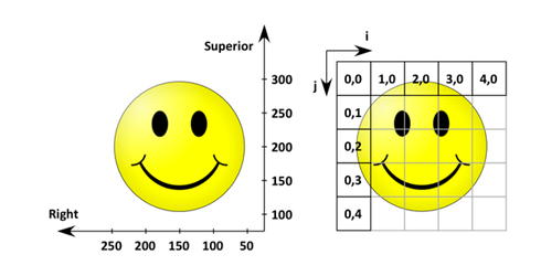
Learning Co-ordinate geometry is not just to clear your present class but also helps your understanding in various ways. Like geometry is applicable in computers or cell phones. The text file or PDF file which we open is itself an example of coordinate plane. In these, the words or images are written or modified with the use of coordinate geometry. Any PDF file, which contains text, images and different shapes, are placed according to the 2-dimentional coordinate (x, y) system. All the concepts like distances, slopes and simple trigonometry are also applicable here.
Drawing any figure on paint brush or editing any image in computer is again a field where concepts of coordinate are used. On changing any shape or adding different colours changes the points on the coordinate plane. Scanner and photo copying machine also uses coordinate geometry to produce the exact image of the original image provided to it.
So, here we got to know few applications wheretheconcepts of geometry are used.
- Describing position of any object
Coordinate system can be used to find the position of any object from its original place (called origin) to its present location. For example, we can find the distance at which the watch is placed on the television from the opposite corner of the room. Let the horizontal distance of television from the corner is 10 meters and the vertical distance of the watch from the ground is 5 meters. If room is 5 meters wide, then we can easily find the coordinates of the watch and thus can apply the distance formula to calculate its actual distance.
- Location of Air Transport
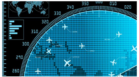
We all have seenthe aero-planes flying in the sky but might have not thought of how they actually reach the correct destination. Actually all these air traffic is managed and regulated by using coordinate geometry. Coordinate geometry is a tool which will answer our following questions:
What is the current location of an aircraft?
How much time is required from one place to another travelling at certain speed? And many others.
All the air traffic is controlled by air traffic controller. A Controller must know the location of every aircraft at any particular instant of time in the sky. Coordinates of any particular vehicle are used to describe its current location of the aircraft. Even if an aircraft moves a small distance (up, down, forward or backward), its coordinates are updated in the system.
Now imagine what if coordinate system doesn’t exist. Pilots, aircraft controller, passengers in the flight, persons waiting for the flight all will not be able to get the location or position of aircraft. These will also definitely increase the chances of aircraft crashes.So from here we can easily say that coordinate system is one of the most important parts of air transport.
- Map Projections
Map Projection is a technique to map any 3D curved object on a flat 2D surface. For example, to represent the curved surface of earth on a flat map, this technique can be used. For these purpose, a special type of coordinate system is used called as a projected coordinate system. These are mainly used to represent the maps on computer screen.
Both two-dimensional (2D) and three-dimensional (3D) cartesian coordinate systems are helpful in describing shape of features and the geographic location using x- and y-values.Horizontal (x) and vertical (y) are the two axes used in any 2D Cartesian coordinate system. Here horizontal axes represent east-west, and vertical axes represent north-south directions. Here the point of intersection is the origin. All the locations of geographical objects are described relative to the origin only. Any point in Cartesian coordinate is denoted by (x, y), where x refers to the distance along the horizontal axis and y refers to the distance along the vertical axis. The origin is defined as (0,0).
- Latitude and longitude
For the real world locations, describing the accurate location and shape of features will require a coordinate framework. So for these purpose, a special coordinate system called geographical coordinate system is used to assign geographic locations to objects.You might have studied latitudes and longitude in geography, these measurements are actually used to accurately point any place or object on the earth’s surface. These are much similar as the normal x – y coordinate system or the polar form of the coordinate system.They are measures of the angles (in degrees) from the center of the earth to a point on the earth’s surface.
A latitude measurement indicates locations at a given angle north or south of Earth’s equator. So, latitude measurements range from 90° North at the North Pole to 0° at the equator to 90° South at the South Pole.
A longitude measurement indicates locations at a given angle east or west of an imaginary north-south line called the prime meridian, which runs through Greenwich, England. Longitude measurements begin at 0° at the prime meridian and extend 180° both to the west and to the east.
In real life, when weather forecasters are tracking hurricanes, they note the absolute location on a periodic basis to see the path of the storm and try to predict the future path based partially on these findings.
Apart from all these, I am sure, most of you have used GPS in your smart phones. The Global Positioning System (GPS) is a space based satellite navigation system that provides location and time information in all weather conditions.
In a GPS, the longitude and the latitude of a place are its coordinates. The distance formula is used to find the distance between 2 places in a GPS.
I hope, after reading this article, you got to learn something new and interesting real life applications of coordinate geometry which we learn in junior and senior classes.
I am Vijay Mukati, Mathematics Expert at askIITians. I did my post-graduation from IIT Patna. For more about me you can visit the following link
Online Study Packages Prepared by me:
Best of Luck to you all. Study well and always try to relate the concepts you read with the real life examples. Definitely for this you need to think!! For any queries please do ask us or you can post any question on our free forum.
Author: Vijay Mukti


